New Report: Development of a Volcanic Tsunami Threat Level Database
A GNS Science Report has been published that describes the development of a Volcanic Tsunami Threat Level Database for New Zealand.
Access the report here.(external link)
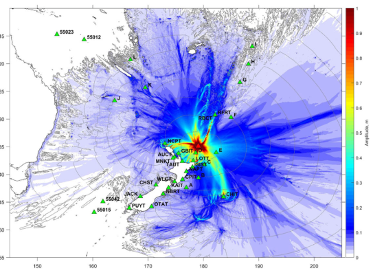
When the Hunga Tonga – Hunga Ha-apai volcano in Tonga erupted in January 2022, it generated tsunami that reached the New Zealand coast. There were no pre-computed volcanics tsunami scenario readily available to assist with the tsunami response.
The new database is a pre-calculated volcanic tsunami threat level scenario database that provides tsunami threat levels (e.g. no threat, beach and marine, land threat) for, and travel times to, New Zealand’s coastal tsunami warning zones. It also provides tsunami travel time estimates, and waveform plots at coastal gauges and offshore DART stations. The DART (Deep-ocean Assessment and Reporting of Tsunamis) buoys provide a real-time monitoring system for tsunami.
The Raranga Whāriki Papa Moana | Beneath the Waves research programme supported the development of localised volcanic tsunami source model and dispersive wave / tsunami simulation model for offshore volcanoes used in this study. Tsunami researchers at GNS Science in a pilot study, simulated tsunami from 28 selected inland and offshore volcanoes around New Zealand.
The new database improves the Tsunami Experts Panel and the National Geohazards Monitoring Centre's capability and reduces decision-making time in response to future volcanic tsunami events. In a real event, the estimates would be further scaled and adjusted based on tsunami signals recorded at DARTs and coastal tsunami gauges.


Xiaoming Wang
Project Leader: Simulate & Tsunami Scientist