Papamoa Evacuation Modelling
A recently published study used Agent Based Modelling (ABM) as a tool to evaluate the potential for the population of Papamoa to be able to leave the evacuation zone on foot within the time available, and to try and identify obstacles that could prevent a successful evacuation and identify potential improvements that could assist.
Download the report here.(external link)
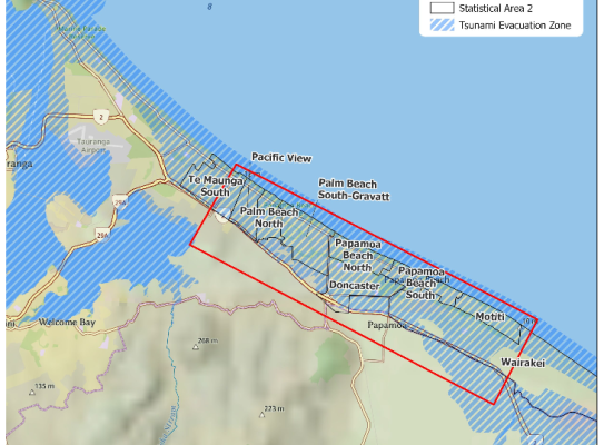
Papamoa is a suburb of Tauranga in the Bay of Plenty which has undergone remarkable population growth in recent years. As a low-lying coastal town, it is vulnerable to tsunamis, and in particular to tsunamis caused by earthquakes on the Kermadec subduction zone which lies to the north-east of the Bay of Plenty. Tsunamis from the southern part of the Kermadec subduction zone are expected to reach the Papamoa coastline around 50 minutes after the earthquake. It is consequently important that the population are able to promptly respond to Long or Strong shaking in the event of such an earthquake by self-evacuation from the tsunami evacuation zone.
In our study we have used Agent Based Modelling (ABM) as a tool to evaluate the potential for the population of Papamoa to be able to leave the evacuation zone on foot within the time available, and to try and identify obstacles that could prevent a successful evacuation and identify potential improvements that could assist. Agent Based Modelling is a technique in which the movement of ‘agents’, who are simulated individual people, is calculated by numerical modelling. In this case we model agents as pedestrians attempting to leave their homes or workplaces and reach the safe area outside of the evacuation zone.
Key findings:
- The importance for successful evacuation of people making the decision to evacuate and leaving their homes or workplaces promptly.
- Many of the simulated people in eastern/central Papamoa use routes across farmland to evacuate, and as these routes are not available all year round, a recommendation is made to plan for alternatives.
- The number of people making use of Vertical Evacuation Structures (VES) such as the Gordon Spratt Evacuation Mound, and the similarly isolated area around the Te Manawa school, is hard to predict, and further work to understand public attitudes to the use of VES is recommended.
- There are several drainage channels in Papamoa running parallel to the coast, which are not safely crossable by pedestrians except at bridges. The provision and location of future bridges across these channels should be carefully considered with evacuation in mind.

William Power
Geophysicist