Summary of Voyage #4: Imaging sub-surface electrical resistivity structures
The focus of our fourth research voyage, in April 2024, was to re-deploy and recover ocean-bottom sensors around Whakaari and Tūhua island volcanoes. We also undertook surface-towed Controlled Source EM (CSEM) and deep-towed Self-potential (SP) surveys to image electrical resistivity structure at more shallow depths (few hundred metres) across the Calypso Geothermal Field and on the southern flank of Whakaari.
The team from Raranga Whāriki Papa Moana | Beneath the Waves programme are undertaking a series of research voyages to learn more about the anatomy and dynamic hazard processes of Tūhua (Mayor Island) and Whakaari (White Island) volcanoes. This article summarises the key activities undertaken in April 2024 aboard the RV Tangaroa.
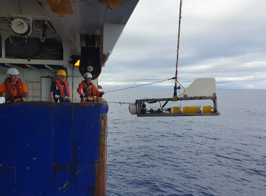
Ocean Bottom ElectroMagnetic (OBEM) Deployments
On this voyage, we recovered, re-deployed and then, for the last time, recovered Ocean Bottom ElectroMagnetic instruments (OBEM). These instruments passively measure natural electric and magnetic fields in the Earth’s crust. Modelling of the MT (magnetotelluric)(external link) data collected allows us to image the electrical resistivity structure in the crust to tens of km’s depth, including imaging the underlying magmatic systems at Whakaari and Tūhua.
In total, we have made 182 OBEM measurements as part of the BTW Programme. The OBEM instruments have been deployed over a series of voyages (i) in November 2022 (TAN2214) -January 2023 (MV Toanui)(external link), (ii) in October 2023 (TAN2315)(external link), and (iii) most recently in April 2024 (TAN2403). Together, these deployments cover an extensive area around and between Whakaari and Tūhua island volcanoes.
Controlled Source Electromagnetic Surveys (CSEM)
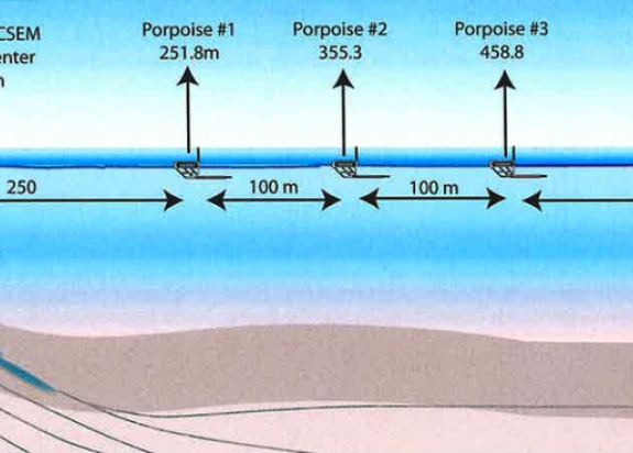
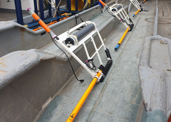
CSEM measurements are based on the electrical resistivity difference between a target reservoir and its surrounding rock. The CSEM instrument used on the voyage was the Porpoise system developed by Scripps Institution of Oceanography (SIO), which is a surface towed system designed to operate in shallow (<200 m) waters.
The objectives of the CSEM surveys were to:
- Image the submarine flanks of Whakaari in water depth < ~200 m for volcanic structure, particularly hydrothermal alteration and fluids within the lower flanks of the volcano.
- Image fluid distribution within the Calypso geothermal field.
- Image deeper (1-2 km) crustal structure along a transect over OBEM receivers at the southern end of Calypso.
The CSEM streamer was 750 m long and consisted of a dipole and 5 “porpoise” receivers, towed at approximately 3 knots. Data is recorded independently on each porpoise and the transmitter is controlled from the ship.
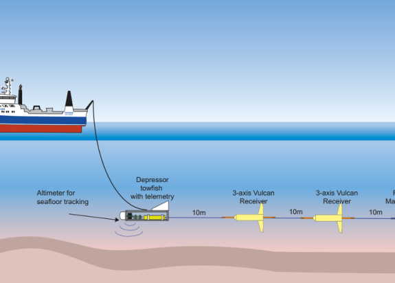
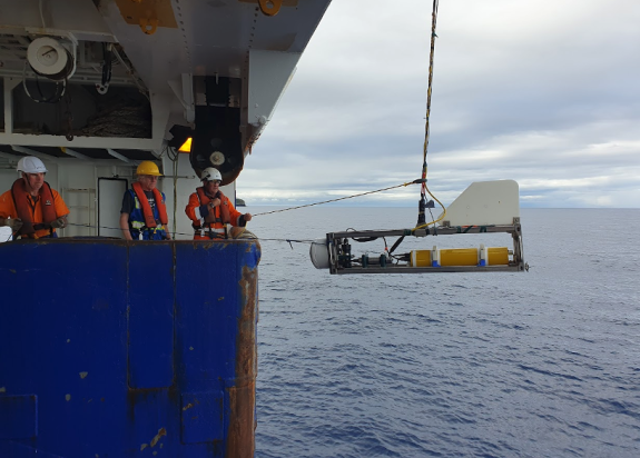
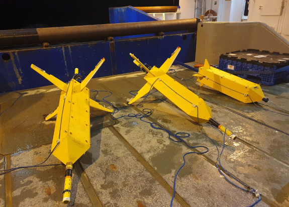
Self-Potential Survey
Marine self-potential (SP) is used to explore for hydrothermal venting and associated seafloor mineralisation. It is based on the study of natural electric fields (i.e. not created by an artificial source).
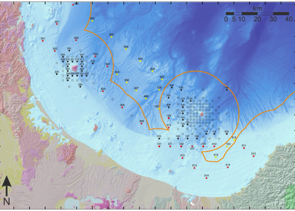
To detect fluid flow within the crust, deep-towed self-potential surveys were undertaken over the Calypso geothermal field (approximately 10 km southwest of Whakaari, in 180-200 m water depth) and over the south-west flanks of Whakaari. These SP survey lines targeted MAPR anomalies detected using the AUV Sentry during TAN2306(external link) (April 2023).
The SP set up consisted of a depressor stage that sets the altitude above bathymetry (e.g. 50-100 m), followed by two Vulcan units that record 3 axis electric field, followed by a final unit with fluxgate magnetometer. The string is towed at around 1-2 knots, or the minimum speed required to maintain steerage depending on the wind and swell conditions.
Building 3D geophysical volcano ‘anatomy’
Data from TAN2403 contributes to building 3D geophysical “volcano anatomy” models of Whakaari and Tūhua. The OBEM results will provide a snapshot of the present location and state of the magmatic and hydrothermal systems vital to correctly interpret monitoring data. The shallow sensing CSEM and SP surveys will provide context for anomalies detected with AUV SENTRY on TAN2306(external link), and will also merge with pre-existing magnetic maps, SkyTEM surveys(external link) of Whakaari and the much deeper sensing OBEM measurements.
Thank you to the Master and crew of TAN2403 for outstanding support of our science objectives.
VOYAGE INFORMATION
TAN2403 RV Tangaroa
Dates: 28 March – 12 April 2024
Lead Organisation: GNS Science
Voyage participants:
- GNS Science: Ted Bertrand (Voyage leader, Chief scientist), Craig Miller (Co-Chief scientist), Wiebke Heise, Alex Caldwell
- Scripps Institution of Oceanography: Steven Constable (Deputy Voyage Leader, Co-Chief scientist), Jacob Perez, Chris Armerding, Roslynn King
- Woods Hole Oceanographic Institution: Bailey Fluegel
- Blake Ambassador Students(external link): Georgina Dempster (University of Otago), Lottie Stow (University of Canterbury)

Ted Bertrand
Geophysicist

Craig Miller
Beneath the Waves Programme Leader & Volcano Geophysicist